Peak Bagging: Bondcliff, Bond, + West Bond
The Bonds had always seemed like an almost impossible feat for me. I’ve peak bagged before, but not on a trail that would see me hiking 22 miles. So, it was a daunting thought that I had agreed to do this hike, particularly because it was November, cold, and we’d be sleeping on the mountain in below freezing temperatures. But I saw my old boss who has gotten into hiking recently, and we decided to tackle some 4000’ers together. This trip brought me up to 16/48 for the year!
The first (and last because of the roundtrip o/b) ~5 miles of this hike is very flat. Then, the rest of the hike is pretty gradual in incline. The White Mountains are known for having difficult trails, and you’d think this one would be too but it’s not! I was so pleasantly surprised by how easy this trail actually was. There are a few steep moments but 95% of the trail is flat or has a moderate incline.
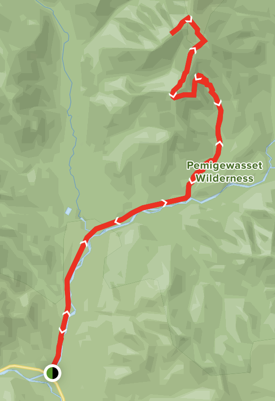
You start on the Lincoln Woods Trail which turns into the Wilderness Trail, and then take a left at a fork for the Bondcliff Trail to reach the first summit, Bondcliff. We took a break here and cooked up some breakfast on the camp stove, and of course we each had to have our photo taken on the cliff- did you even hike Bondcliff if you didn’t get a pic?! Then, we continued along for 1.2 miles to reach the summit of Mount Bond. The trees had a heavy dusting of snow on them, and combined with the view of Mount Washington, it was probably one of the most beautiful views I’ve ever seen, and trust me- I’ve seen my fare share of the world…7 continents worth! From Mount Bond to West Bond you pass the spur trail to reach the Guyot Campsite, which is where we stayed for the night. We left our packs at the fork to West Bond and the campsite, thoroughly enjoying the hike to/from the West Bond summit with no weight on our backs. On West Bond we were greeted by some gray jays. They are the cutest little birds, pretty round and a bit fluffy looking. I assume hikers frequently feed them as I’ve seen many photos of this, but they also were not afraid of us. In fact they probably were sitting in the trees waiting for us to hold out our hands with some crumbs!
The hike down from the West Bond summit to the spur trail seemed to take longer than going up. By this point I was done hiking and just wanted to sit down. When we reached the campsite, and then the shelter, boy was that a happy sight! We got to the shelter just after 3:00pm, and we were in bed by 6:00pm. Maddie and I set up my tent inside the shelter, Simon set up his bivy (didn’t work out so great), and Andrew hammocked. We filled up on freeze-dried dinners, and tried to warm up best we could before turning in for the night. The weather during our hike up could not have been better- sun, clear skies, and no wind. Our stay at the campsite was good too with no wind. My sleeping setup worked out so well that I actually was a little too warm at some points in the night. I also had picked up some Ignik hand warmers from REI that worked fantastic. It was a different brand than I normally buy and I’m gonna stick with them!
Th next morning we were greeted with a sunrise off the porch of the Guyot Shelter. We had a very small, fiery sunrise that was occluded by clouds— which made us very glad we did all three peaks the day before with blue skies. We took our time warming up, having breakfast, and trying to unfreeze our hiking boots. While Maddie held hers over her backpacking stove, my approach was to stuff my feet in them and walk around in pain.
One could have hiked back down without spikes, but they did prove useful in not having to be as careful with your footing. There was also enough snow around the campsite and a mile or so down the trail that snow gaiters would have been nice to have. It was a fantastic hike and I’m so glad I challenged myself to complete it!
All images subject to copyright
PARKING
You can find parking at the Lincoln Woods, off of 112/Kancamangus Highway.
There is a parking fee for the day, paid via envelope,
MILEAGE
22.2 miles out and back
ELEVATION
Bondcliff 4,265’
Bond 4,698’
Westbond 4,540’
TERRAIN
Flat for the first ~ 5 miles with some river crossings, then a moderate incline with some short, steep areas. One point right past the alpine zone sign up to Bondcliff that requires scrambling up a vertical rock face. Moderate trail from Bondcliff to Westbond. The spur trail to the Guyot Campsite is steep.
THE VIEWS
You can view each of the three mountains from their summits. You also have views of the Franconia Ridge, Owl’s Nest, and the Pemigewasset Wilderness.
Trail map via All Trails
GEAR
The Cat’s Meow Sleeping Bag | North Face, Backcountry
Nemo Flyer Sleeping Pad | REI, Moosejaw, Backcountry
NEMO Galaxy 2P Tent | similar here
Osprey Aura AG 65 | osprey, backcountry
MSR Pocket Rocket Deluxe 2P Kit | rei, moosejaw


