An Early Wakeup Call To Hike Tuckerman's Ravine
Tuckerman Ravine is a hike you need to go on if you haven’t already. When the ravine is covered in snow, you may think you’re in Colorado! It is a popular place for extreme skiing, and hundreds of people hike up to the bowl to get in a good shred. If the bowl is too extreme for you, the Sherburn trail goes from the AMC hut down back to the base of the mountain. In the spring you’ll see loads of people hiking or skinning up. Even in the early summer of June you can still find snow up there and the occasional skier. Being Mount Washington, the weather can get real crazy, real quick, so it is always good to check the weather and know what you’re getting yourself into. And, to ski safe. The bowl has had fatalities from avalanches and people get helicoptered away from tumbling down.
Pulled right from good ‘ole Wikipedia, here are some words about the different routes that you can ski on Tuckerman Ravine:
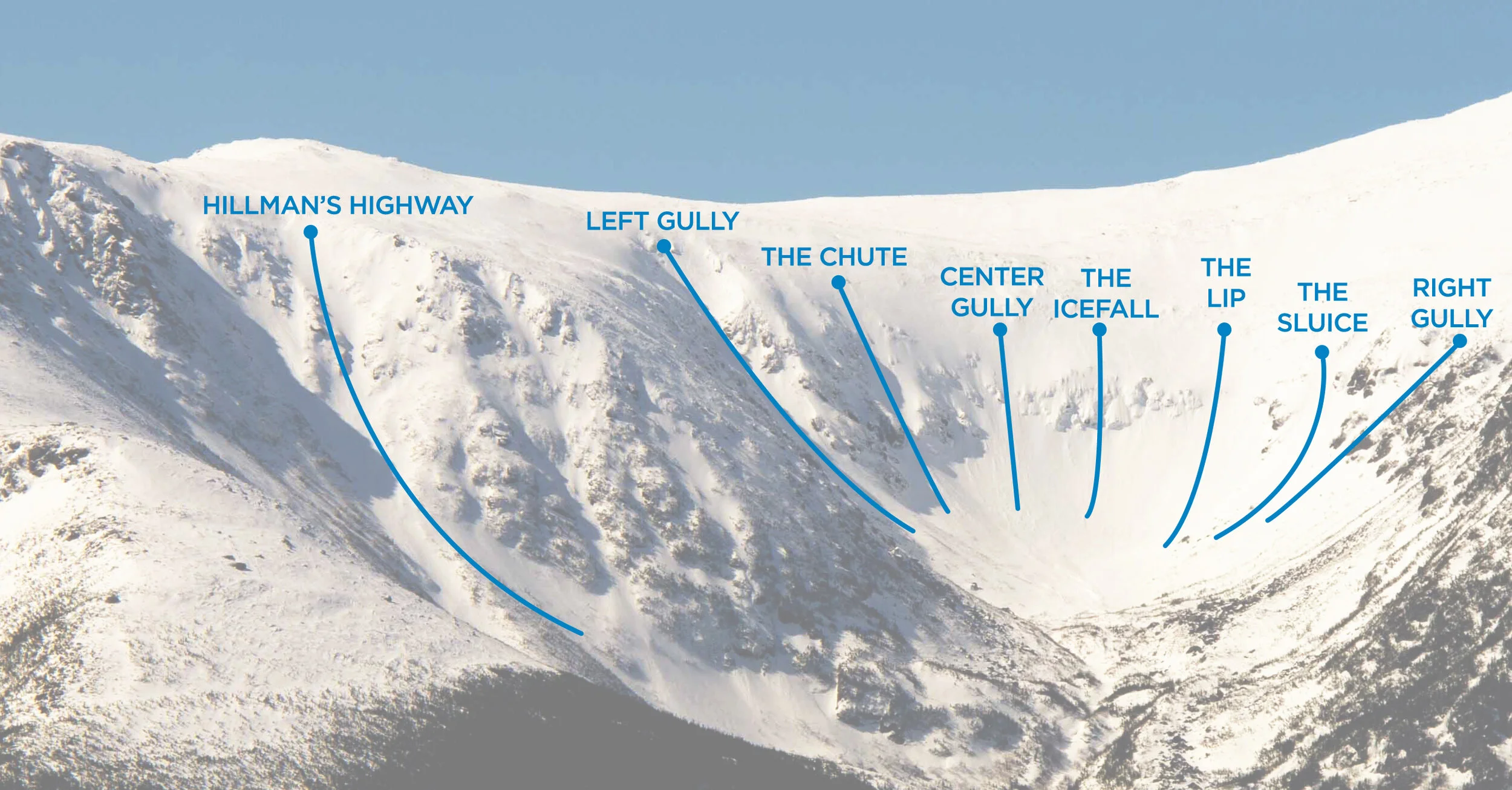
Tuckerman Ravine has many different runs that span the bowl, all as steep as 40 to 55 degrees. From the base of the bowl, the run farthest to the left is known simply as "Left Gully" and is one of the easiest runs. Moving to the right, the runs are more challenging and steeper. More to the right, "The Chute" drops between two large cliffs that slowly narrow the run. Still farther to the right are the Center Gullies, which includes "The Icefall", which is 55 degrees, and requires skiers to go off cliffs as tall as 25 feet (7.6 m). Right of "The Icefall" is "The Lip". It is an open run that averages between 50 and 55 degrees. "Right Gully", one of the bowl's easier runs, drops into "The Sluice" about halfway down, and averages about 40 degrees.
Now- for the Inferno. March 20th, 2021 was the Tuckerman Inferno. It is a pentathlon consisting of a 6 mile fat bike on the Great Glen Trails, 6 mile xc ski on the Great Glen Trails, 5 mile snowshoe from the Great Glen Trails to Connie’s Way (a back country ski trail), a 3+ mile mountain run up the Tuckerman Ravine Trail to the base of the bowl, and then a ski/snowboarding giant slalom in the ravine.
You can enter the race as a team of five, or you can enter it solo and do all five legs yourself. My boyfriend had a friend enter as a solo competitor so we went up to watch the race go by at Hojo’s, which is an AMC cabin right before the path to go up to the bowl.
We started up the mountain at about 5:00-5:30AM. EARLY. But, it was sooo worth it! We had headlamps but it started to get a little light pretty early on so we didn’t need them for that long. There were a few other people that we passed on the way up, all skinning. Simon was skinning too, and I was walking. I used spikes and I have to say they were super helpful. The snow was packed down, but it was good just to keep my footing and not slide. Because of the snow, the trail was way less technical and I found it to be moderate. I did it last summer, and then I would have said it was hard- just steeper inclines and lots of rocks etc to give your glutes a good burn.
The bowl was super cold and windy so I only stayed up there for around 30 min, it is crazy how much of a difference it was from the bowl to Hojo’s, and it is only .7 miles apart from each other (and minimal elevation gain to the bowl’s base). The trip down was super quick, around 40 minutes. By that time the sun was beating down and I had to shed some layers. The snow was also softening up but I kept my spikes on to help with the grip.
MY STATS
Winter ascent from Pinkham Notch Lot to Tuckerman Ravine: ~2.25 hours
Winter descent from Hojo’s to Pinkham Notch Lot: ~40 min (some running involved)
Total moving time: 3:03:22
Total elapsed time: 5:44:48
PARKING
Pinkham Notch Visitors Center
MILEAGE
4.7 miles roundtrip. Add another 1.6 miles if you go up to the ravine.
TERRAIN
In the winter the snow is nice because the trail is pretty smooth so there isn’t a ton of technical footwork that needs to happen. Spikes are helpful to have, especially once it gets warm out and the snow starts to melt- they’ll help prevent you from sliding around. Lots of people skin up when there is snow on the trail, so that tells you how manageable the terrain is! In the summer, lots of rocks to step over, but no scrambling involved. It is a steep hike but a steady-steep.
THE VIEWS
From Hojo’s, you have an incredible view of the ravine. You can also go to the lake which is right nearby the hut, and get lake views and ravine views. If you have it in you to hike a little further past the hut, head up to the ravine. You’ll find people skiing down the ravine up until the snow melts.
GEAR
Moncler Bady | moncler, saksfifthavenue
66° North Sweater | 66north
Lululemon Swiftly Tech LS Tee | lululemon
Fjallraven Abisko Trail Tights | backcountry, rei, moosejaw
Cotopaxi Headlamp | no longer in circulation
Hillsound Trail Crampons | rei, hillsound, moosejaw


